Cook Bay (South Georgia)
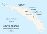
Bay in South GeorgiaCook Bay is an irregular bay, 1.3 nautical miles (2.4 km) wide at its entrance between Cape Crewe and Black Head, narrowing into two western arms, Lighthouse Bay and Prince Olav Harbour, along the north coast of South Georgia. It was charted by Discovery Investigations (DI) personnel during the period 1926–30, and named by them for Captain James Cook, who explored South Georgia and landed in this general vicinity in 1775.
Read article
Top Questions
AI generatedMore questions